

Magnetometro
MAGNETOMETER INTEGRATED WITH A DRONE FOR DETECTION OF METAL OBJECTS
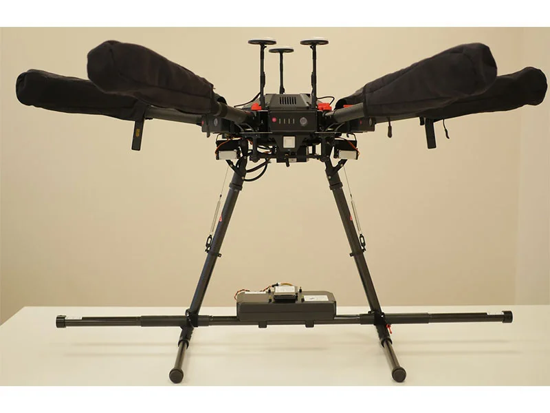
The integrated system combines a drone with sensitive magnetometer
SENSYS MagDrone R3 and true terrain following with precise altimeter.
Typical applications are:
• Searching for UXO (unexploded ordnance)
• Locating buried infrastructure (metal pipes and shielded cables)
• Archaeology
• Surveying for any metal objects weighing a few hundred grams or heavier lying underground
SENSYS MagDrone is a Fluxgate magnetometer system and is therefore able to detect any magnetic metals/materials.
A very important point is that magnetometer is not an active sensor. It measures magnetic field at the point where it is located. So for detection of objects (especially small ones) it is very important to fly as close to the surface as possible. True terrain following system with precise laser altimeter allows to fly as low as 1m AGL.
Using a magnetometer on a drone enables to scan the area and detect metals several times faster compared with handheld devices and allows obtaining geo-referenced maps of the area.
One of the main components of the integrated system that enabled efficient survey planning is UgCS – a flight planning software that provides tools for easy creation and calculation of flight paths. To plan a survey mission with UgCS, just mark the area of interest on the map and start an automatic flight mission.
FEATURES OF THE INTEGRATED SYSTEM
Compact and simple to use system
MagDrone R3 is a light and compact magnetometer system. Almost any drone with payload capacity of 1KG can be used. We recommend DJI M600 Pro, M210, M210V2 or medium/large drones with Pixhawk autopilot.
Thanks to 200Hz sampling rate MagDrone R3 can be attached to the drone’s legs without detrimental effects. High sampling rate allows filtering out noise from the drone’s motors and electronics. It is a huge benefit compared with traditional magnetic sensors on the rope under a drone, especially for inexperienced drone pilots.
Integration with the drone
Power for MagDrone R3 provided from the drone’s main battery eliminates the need to have one more set of batteries in the field.
Easy to use software to process the data
MagDrone R3 comes with the SENSYS DataTool software:
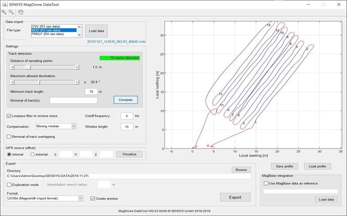
Data Tool has 4 main functions:
• Detecting tracks to extract separate survey lines from recorded data
• Basic data filtering (low pass filter, compensation for the Earth’s magnetic field and removing the overlap between tracks)
• Exporting to various formats (including CSV, both RAW and after filtering)
• Previewing magnetic data
Preview window allows to access collected magnetic data in seconds without having to deal with complex geophysical software:
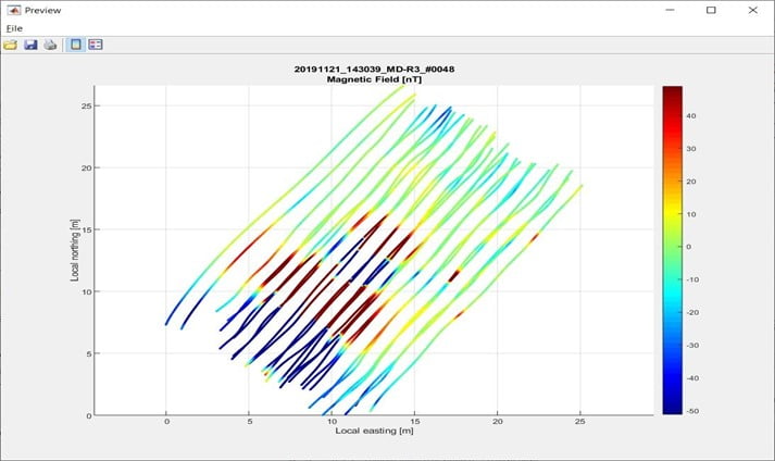
For further processing and visualization, we recommend SENSYS Magneto or Geosoft Oasis Montaj – or any other software capable of importing and visualizing geotagged scalar data.
Automatic terrain following with laser altimeter
The amplitude that the magnetometer is measuring decreases by the 3rd power of the distance. Below are samples of data gathered from the same place using different flight altitude. There are 2 pieces of metal pipes (with a diameter of 2 inches and 1 inch) hidden underground.
1m AGL:
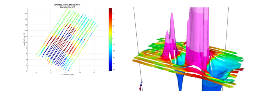
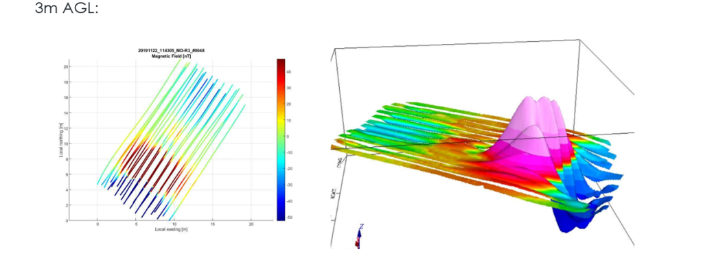
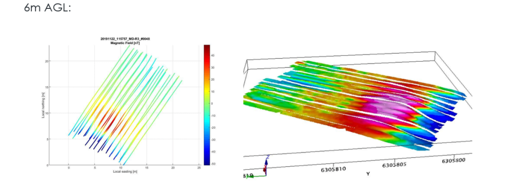
The preview was generated with SENSYS MagDrone DataTool, and the 3D surfaces were created using Geosoft Oasis Montaj. Vertical scale is the same on all 3D surfaces. Dependency of amplitude of measured values on the distance is clearly visible in these samples.
UgCS True Terrain Following with laser altimeter allows flying in automatic mode as low as 1M AGL providing possibility to detect small objects and gather high-resolution data.
>Magnetometer Main features:
• Patented, ultra-low “NanoPower” communications protocol
• Superior accuracy, dependability, and extensibility
• Universal platform for all traffic detection applications
• Self-calibrating, self-tuning
• Re-usable and remotely upgradeable
• Easily deployed in complex configurations
• Capable of over 300 million detections
• Ability to enable temperature reporting
• Sampling rate: 32/128 Hz
• Reliable 2-way radio communications with Sensys Networks gateways
Parla con un nostro Esperto
DroneBase ti mette a disposizione un Consulente Esperto
in grado di consigliarti il prodotto più adeguato alle tue necessità
e rispondere a tutte le tue domande.
Chiamaci ORA!
+39.0541.1790411
Richiedi informazioni
Inserisci i tuoi dati quì sotto, il nostro consulente ti
ricontatterà al più presto e ti fornirà tutti i dettagli!
