Thermography
Professional Drones for Thermography
Systems
Integrated
Rooms
30X Zoom
Images
Radiometric
Cloud
Software
Professional Solutions for Thermography
Thermographers and Specialized Technicians are increasingly integrating the use of Professional Drones for their work
daily thanks to increasingly high-performance technology and increasingly affordable prices.
NOT JUST DRONES BUT INTEGRATED SOLUTIONS FOR THERMOGRAPHY
Thermographic inspection is not just about the drone. These are integrated UAV systems with calibrated Radiometric sensors,
High precision GNSS RTK systems, software, workflow, training and support.
Our Thermal Packages include High Performance Drones with Calibrated Sensors and Advanced Software,
Systems designed for rapid learning and easy use,
so that you can get your Drone services off the ground immediately for
Photovoltaics, Structural Inspection, Thermal Efficiency.
The advantages of drone thermography
Welcome to the future of thermographic inspection and monitoring, where technology meets efficiency
Through the innovative use of drones. Drone thermography represents a revolutionary breakthrough in thermal analysis,
bringing with it significant advantages in speed, accuracy and safety.
Unparalleled efficiency:
Thanks to the flexibility and maneuverability of drones, thermography is reaching new levels of efficiency.
Drones can easily explore areas that are difficult for humans to access or dangerous,
ensuring complete and rapid coverage of complex structures, industrial facilities, power lines and more.
Real-time accuracy:
Drone thermography provides real-time data, enabling instantaneous analysis
Of the thermal conditions in the area of interest. This timeliness enables operators to make quick and informed decisions,
optimizing asset management and identifying potential problems before they become serious.
Safety first:
Eliminating the need for manual inspections in hazardous or difficult-to-access locations,
drone thermography helps ensure the safety of operators.
By reducing human risk in inspection activities, occupational safety is greatly improved.
Versatile applications:
From preventive maintenance to energy loss detection, from infrastructure surveillance to environmental monitoring,
drone thermography has countless applications. The versatility of this technology makes it a key ally
in sectors such as energy, construction, industrial maintenance and environmental management.
Sustainability and cost reduction:
The adoption of drone thermography not only improves operational efficiency, but also contributes to environmental sustainability.
By reducing the need for human resources and traditional vehicles for inspection, emissions and associated costs are reduced.
In conclusion, drone thermography is an advanced solution that revolutionizes the way
In which we address thermal inspection and monitoring. By harnessing the power of drones, we are able to obtain more accurate data,
in less time and more safely, paving the way for a more efficient and effective future.
1 MW
scanning
max per flight
4.5 cm/px
maximum
GSD
640p
maximum
resolution
5.0 cm
error
in RTK/PPK
60 min
maximum time
flying
5 km
maximum radius
acting
Discover our Combo Thermal for
Photovoltaics and Thermal Inspection
The combos in the Thermal range include everything professionals need
(Drones, Sensors, Software) for Photovoltaic, Wind, Structural Inspection and Energy Efficiency.
Aerial Thermography is not only about the drone.
DroneBase provides integrated systems, complete with Calibrated Sensors and precision GPS,
Specific flight planning software and APPs,
accurate workflows, post processiong software, professional training and support.
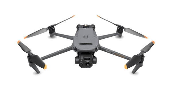
Mavic 3
Thermal
Cheaper solution
- Mavic 3 Thermal - Care 1 Year
- DJI Mavic 3 Enterprise Battery Kit
- Silver 2-hour remote support (5 tickets)- Telehealth
- Complete enac manuals + d-flight portal registration
Complimentary:
- Dronist's fee schedule 2023
- Drones: how to fly in the red zone legally
- Guide to mandatory drone insurance
yours from 115.00 Euro/month with grenke operating rental
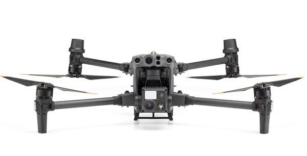
Matrix
30T
Chosen by 79% of our customers
- 30T Matrix
- 4 x DJI TB30 Intelligent Flight Battery
- Silver remote support 2 hours (5 tickets)- Teleassistance Complete enac manual + d-flight portal registration
Complimentary:
- Dronist's fee schedule 2023
- Drones: how to fly in the red zone legally
- Guide to mandatory drone insurance
yours from 259.00 Euro/month with grenke operating rental

Effective
All In spection Kits are designed to acquire large areas better and faster without disrupting site work or activities

Precise
High-resolution RGB sensors, Radiometric Thermal Cameras united Laser Range finder and 3D Lidar ensure the highest level of accuracy and detail at all times.

Safe
Difficult to access or dangerous areas will no longer be a problem with our Inspection solutions always ready to take off in a few moments, safe and reliable in all conditions

Competitive
Drone inspection provides reduced field acquisition time and drastic reduction in post processing time allowing you to be more competitive
What results can I achieve?
- 2D Radiometric Digital Models
- Georeferenced Radiometric Images
- Cartographic representation (georeferenced orthomosaics)
- Accurate Reports
- Visual data analysis AI
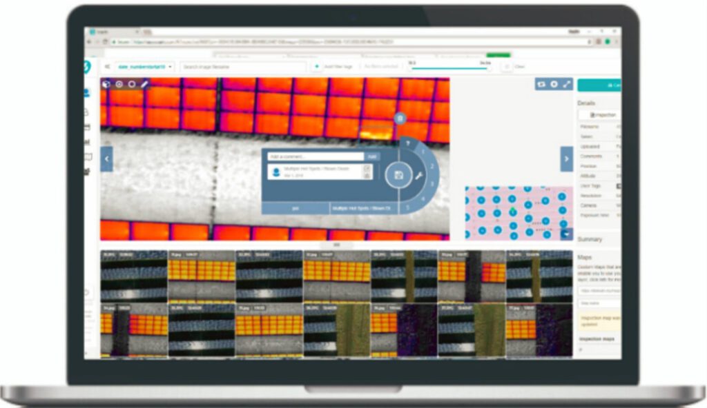
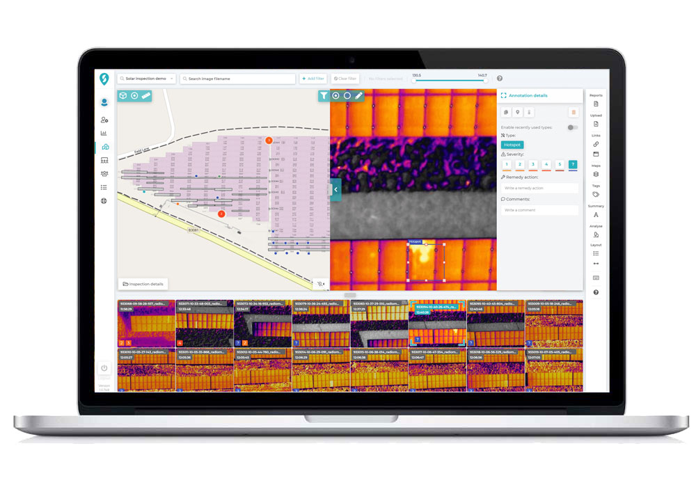
Processing and Reporting
Thanks to cloud interfaces combined with artificial intelligence today analyzing thermal data and creating reports has become fast, accurate, and inexpensive! Our platform uses Automated Machine Learning to derive very important information from your geospatial data. Over time, historical inspection data will become the catalyst for powerful predictive maintenance.
Managing large amounts of images and data will no longer be a problem thanks to our cloud platform specifically designed for Photovoltaic, Wind, Powerline and Buildings
Talk to one of our Experts
DroneBase provides you with an Expert Advisor
Able to recommend the most appropriate product for your needs
And answer all your questions.
Call us NOW!
+39.0541.1790411
Request information
Please enter your details below, our consultant will
will contact back as soon as possible and provide you with all the details!
