COMPLETE 3D DRONE LIDAR SCANNING SYSTEMS
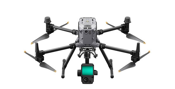
DroneBase offers various 3D Lidar solutions for Drones, with Dual and Triple ECHO sensors up to 64 channels and 1,280,000 points.
Thanks to the Inertial platform and centimeter RTK/PPK correction, no ground control points are needed and are returned
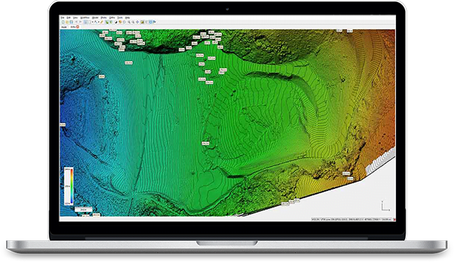
Geometric measurements with centimeter accuracy. When using Triple ECHO, during the detection
in forested areas, the upper part of the vegetation is differentiated from the ground and the detection area of the
soil (DTM) is directly displayed which drastically simplifies Classification operations.
Like terrestrial Lidars, drone Lidars also achieve very high performance in terms of Accuracy and Scanning Capability
also allowing dynamic scanning of large areas, Bridges, Viaducts, Power Lines, Pipelines and large structures in general.
creating a “new” vision impossible to achieve with terrestrial laser scanners, capable of creating
High-density, colorful point clouds from perfectly calibrated and laser-aligned high-resolution cameras,
a real revolution for this type of application.
Use
Professional Drones
equipped with 3D Lidar sensors makes it possible to scan
of large structures such as bridges and viaducts rather than assets such as Power Lines and Gas Pipelines in a very short time, with great accuracy and maximum safety.
Lidar sensors up to 64 channels and 1,280,000 equipped with RTK/PPK Centimeter Georeferencing Systems and Up to 45mp Camera
take Aerial Lidar Scanning with Drones to a new level never before achieved by traditional methods.
Thanks to Professional Drones with 3D Lidar it is possible to determine features and measurements of an object
without coming into contact with it, create accurate and Measurable Digital 3D models.
Measurements are taken and saved locally (a posteriori, after the survey) and thus can be repeated,
modified and checked several Times.
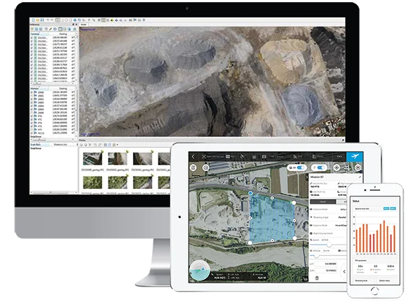
Flight planning software combined with artificial intelligence allows automatic scans to be planned,
anti-collision sensors ensure maximum safety in all flight conditions, cloud-based post-processing software
They also automate the 3D analysis and reconstruction process without the need for expensive workstations and software and
difficult to manage.
Points
Beaten
Triple
Return
Camera
Integrated
accuracy
in RTK/PPK
maximum time
flying
Of Scan
per flight
The combos in the Lidar range include everything professionals need
(Drones, Sensors, Software) for Bridges and Viaducts, Wind, Powerline and Pipeline, Large Facilities.
3D Lidar Aerial Scanning is not only about the drone.
DroneBase provides integrated systems, complete with 3D Lidar Sensors, integrated cameras up to 45mp, combined with ultra-high precision GPS RTK and IMU, specific Flight Planning Software and APPs, with ad hoc tools for horizontal and vertical scans,
accurate workflows, post processing software, professional training and support.
Complete solution
All 3D Lidar Kits are designed to capture large areas better and faster without interrupting work or site activities
Calibrated Lidar Sensors, Chambers up to 45mp combined with IMUs and GNSS RTK and PPK Systems ensure the highest level of precision with accuracy down to the centimeter at all times
Difficult to access or dangerous areas will no longer be a problem with our Mapper solutions always ready to take off in moments, safe and reliable in all conditions
3D Lidar survey with drone provides reduced field acquisition time and drastic reduction of post processing time allowing you to be more competitive
WITHOUT GCPs
Brand new GNSS RTK module for Drones collects positioning data with centimeter accuracy (1cm+1ppm) a new and absolute accuracy (1.5cm+1ppm)
A NON-RTK drone needs 40 to 80
ground control points (GCPs) per square kilometer, which generally
requires hours of preventive work, sometimes very difficult depending on the land conformation.
With a RTK Drone it is possible to acquire up to 200 hectares per hour with very high accuracy drastically cutting field time and optimizing post processing.
DroneBase provides you with an Expert Advisor
Able to recommend the most appropriate product for your needs
And answer all your questions.
Please enter your details below, our consultant will
will contact back as soon as possible and provide you with all the details!

© 2023 all rights reserved
WhatsApp us
Grazie per il tuo interesse nelle nostre applicazioni.
Compila il Form qui affianco per ricevere:
Richiedi una consulenza con un nostro Esperto per Indicarti la Migliore soluzione per la Tue
Necessità!
Grazie della tua fiducia.
Team DroneBase
Thank you for your interest in our applications.
Fill out the Form next to it to receive:
Request a consultation with one of our Experts to Point you to the Best Solution for Your
Necessity!
Thank you for your confidence.
Team DroneBase
Thank you for your interest in our solutions
Fill out the Form opposite and you will be contacted
by one of our Expert Advisors who will provide you with
The Best Solution for Your Need!
Thank you for your confidence.
Team DroneBase
Thank you for your interest in our applications.
Fill out the Form next to it to receive:
Request a consultation with one of our Experts to Point you to the Best Solution for Your
Necessity!
Thank you for your confidence.
Team DroneBase
Thank you for your interest in our applications
Fill out the Form opposite and you will be contacted by one of our Expert Consultants who will provide you with the Best Solution for YOUR NEEDS!
Thank you for your confidence.
Team DroneBase
Thank you for your interest in our Video Surveillance solutions
Fill out the Form opposite and you will be contacted
by one of our Expert Advisors who will provide you with
The Best Solution for Your Need!
Thank you for your confidence.
Team DroneBase
Thank you for your interest in our applications.
Fill out the Form next to it to receive:
Request a consultation with one of our Experts to Point you to the Best Solution for Your Need!
Thank you for your confidence.
Team DroneBase
Thank you for your interest in our applications.
Fill out the Form next to it to receive:
Request a consultation with one of our Experts to Point you to the Best Solution for Your
Necessity!
Thank you for your confidence.
Team DroneBase

