

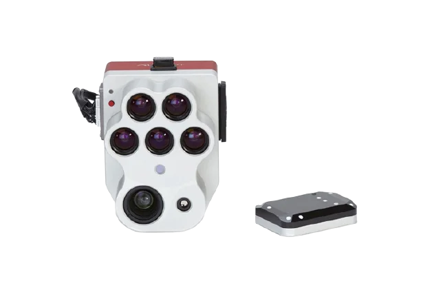
Micasense Altum-Pt.
Micasense Altum-Pt.
RADIOMETRIC THERMAL IMAGING CAMERA FOR DRONES
Altum-PT Drone Thermal Camera, the smallest and most compact thermal camera designed for drones on the market today. Remote control and live video output + dedicated configuration app.

Incrase storage
New professional removable storage standard in CFexpress, enabling over two captures per second, immediate turnaround time between flights by swapping cards, and super-fast card-to-computer upload speeds for more efficient data management.
Twice the spatial resolution of the previous altum
Altum-PT features an ultra-high resolution panchromatic sensor which allows for "pan-sharpening" the multispectral imagery, Ultimately increasing the spatial resolution of the multispectral data: 1.2 cm (0.47in) pan-sharpened ground resolution when flying at 60m (200ft).
Ugradeted thermal sensor
Altum-PT features a built-in 320 x 256 FLIR Boson® that enables thermal maps at twice the ground resolution of Altum - 17cm from 60m flight altitude.
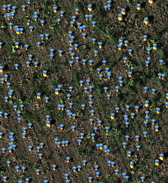
Irrigation scheduling
Determining the time, frequency and duration of irrigation is critical in production agriculture because it has a direct impact on crop health. Altum-PT thermal images provide powerful water management information, helping irrigation managers determine proper irrigation and identify leaks or blockages in the irrigation system through the temperature difference between the crop canopy and the soil.
Diseases, pests and nutrients
With Altum-PT's high-resolution multispectral images, users have a better chance of identifying problems affecting plant canopy physiology. Diseases, insects, and nutrition problems often cause physiological damage before symptoms are visible in RGB. By using the different multispectral indices and composites of the pan-sharpened data, these problems can be detected earlier.
Plant
phenotyping
Manual measurement of plant characteristics is time-consuming. Altum-PT captures more data in less time, allowing researchers to more easily understand how different traits respond to different growth conditions.
Estimation of fruit yield
Popular methods for estimating fruit yield, such as manual fruit counting or time series analysis, are time-consuming and expensive. Altum-PT offers a combination of high-resolution RGB, multispectral, and thermal images, enabling more accurate yield predictions through algorithm-based fruit counting and temperature analysis.
Prediction of water stress
Canopy temperature is a valuable indicator of plant stress. The Altum-PT thermal imaging camera allows farmers to periodically assess the physiological status of plants and detect subtle changes in canopy temperature that could be an indicator of water stress.
Pressure problems and clogging detection
Altum-PT thermal imaging can help identify clogging and irrigation losses through the cooling effects of water or lack thereof on vegetation and soil. Overwatered areas will appear significantly colder than the rest of the field. Areas without irrigation will show higher temperatures than the rest of the field.

Calibrated multispectral images
Each RedEdge-P camera kit is equipped with a reflection panel for ground calibration and a DLS2 light sensor for irradiance and sun angle measurements. These radiometric calibration tools take into account different weather and light conditions, providing more accurate and reliable data that enable time series analysis and comparability of outputs over time.
Powerful AI capabilities
With its panchromatic band, RedEdge-P enables high-resolution RGB and multispectral images for machine learning applications such as plant counting and advanced vegetation research applications.
Altum-PT Sensor Specifications
Weight |
460 g (16.2 oz.) Altum-PT + DLS2 |
|---|---|
|
Dimensions |
11.0 x 8.0 x 6.9 cm |
|
External Power |
7.0 V - 25.2 V |
|
Power Input |
5.5/7.0/10W (standby, average, peak) |
|
Spectral Bands |
Blue 475(32), Green 560(27), Red 668(14), Red Edge 717(12), NIR 842(57) |
|
RGB Color Output |
12.4 MP (global shutter, aligned with all bands) |
|
Sensor Resolution |
2064 x 1544 (3.2MP per MS band) |
|
Multispec GSD (for multispec band) |
5.28 cm per pixel at 120 m |
|
Capture Rate |
2 captures per second raw DNG* |
|
Interfaces |
3 configurable GPIO: select from trigger input, PPS input, PPS output, and top of frame signals. Host virtual button. USB 2.0 port for WiFi. Serial. 10/100/1000 Ethernet. CFexpress for storage |
|
Field of View |
50° HFOV x 38° VFOV (multispectral) |
|
Thermal |
FLIR LWIR thermal infrared 7.5-13.5um radiometrically calibrated |
|
Storage |
CFexpress Card |
* RGB output with appropriate post-processing
*Specifications are subject to change without notice
STANDARD KIT
ALTUM-PT KIT INCLUDES:
– MicaSense Altum-PT Sensor
– DLS 2 light sensor with built-in GPS
– CRP2 calibrated reflection panel
– Wi-Fi USB key
– Lens cap
– Integration cables
– Assorted mounting hardware
– CFexpress paper
– CFexpress card reader
– Hard case
– Introductory guide
DJI SKYPORT KIT
ALTUM-PT KIT INCLUDES:
– MicaSense Altum-PT Sensor
– DJI SkyPort Mount
– DLS 2 light sensor with built-in GPS
– CRP2 calibrated reflection panel
– Wi-Fi USB key
– Lens cap
– Integration cables
– Assorted mounting hardware
– CFexpress paper
– CFexpress card reader
– Hard case
– Introductory guide
Talk to one of our Experts
DroneBase provides you with an Expert Advisor
Able to recommend the most appropriate product for your needs
And answer all your questions.
Call us NOW!
+39.0541.1790411
Request information
Please enter your details below, our consultant will
will contact back as soon as possible and provide you with all the details!
