Description
A powerful and accurate drone detection camera.
High-precision aerial mapping solution
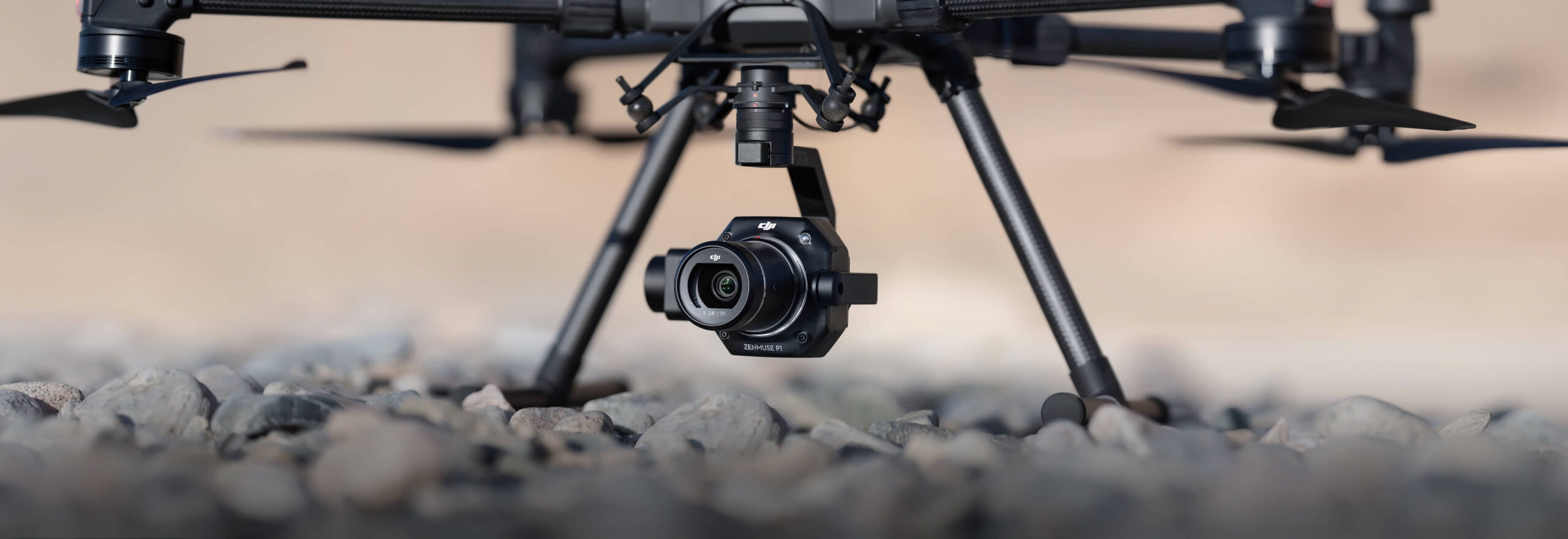
The DJI Zenmuse P1 is a versatile, high-performance sensing payload designed for DJI’s flagship commercial drone, the M300 RTK.
The camera is integrated with a 45 MP full-frame CMOS sensor with 24 mm, 35 mm and 50 mm lens options and a 3-axis stabilized gimbal.
When combined with the M300 RTK drone and the mapping software package, DJI Terra, the P1 camera provides an efficient and high-precision aerial photogrammetry solution.
The integration of the P1 with the M300 RTK greatly increases productivity, being up to 10 times more efficient than the Phantom 4 RTK for orthomosaic and oblique mapping missions.
Highlights include:
- 45 MP full frame CMOS.
- Get a horizontal accuracy of 3 cm and a vertical accuracy of 5 cm without ground control points (3 cm GSD with 75% frontal overlap ratio and 55% lateral overlap ratio).
- High efficiency: coverage of a 3 km² area during a single flight (GSD of 3 cm, with 75% frontal overlap ratio and 55% lateral overlap ratio).
- 3-axis stabilized gimbal with Smart Oblique Capture.
- Mechanical global shutter (achieved with mechanical shutter): shutter speed of 1/2000s.
- TimeSync 2.0: synchronizes flight controller, RTK, gimbal and camera in milliseconds.
MAIN FEATURES OF P1
Collect quality data quickly and securely.Multiple operating modes
The P1 camera has a range of operating modes to enable surveying professionals to capture the best possible data.
These include:
- 2D vegetable garden: collect accurate data quickly and easily, which meets 1: 500 and 1: 1000 cadastral accuracy standards.
- 3D Oblique: multi-angle oblique image data acquired for 3D modeling is provided efficiently and concisely, which can be widely used in many fields such as urban planning, cadastral survey, security command, etc., Helping real 3D and smart cities construction.
- Detailed reconstruction: high-resolution data images can be obtained efficiently to help restore the fine texture, structure, and characteristics of soils and objects. It can be widely used in reconstruction of valuable buildings, protection of old buildings, water protection engineering and geological investigations.
- Real-time reconstruction: Combine with DJI Terra to obtain real-time geographic information of a large area to assist emergency rescue sites.
Smart Oblique Capture Smart Oblique Capture enables the P1 to achieve comparable efficiency in oblique mapping missions compared to five-lens oblique payloads.
- Swing Pattern: when P1 performs an oblique mission in five directions, it will swing in five directions at -60 degrees. It will capture images only within the work area, increasing post-processing efficiency by 20%-50%.
- High oblique operating efficiency: the P1 will perform the multi-angle oscillating shooting pattern to greatly improve operating efficiency on a single-lens camera. The working area with P1 can reach 7.5 square kilometers (GSD of 3 cm, front overlap ratio of 75%, side overlap ratio of 65%) in a single day.
- Higher efficiency: the P1 has higher efficiency in oblique missions than other single-camera payloads.
Multiple Premier lens options
A 35 mm lens is suitable for most mapping missions, but if the drone needs to operate at a higher altitude while maintaining the same resolution, a 50 mm lens option is available.
For flights at lower altitudes, the 24 mm lens can be used.
The comparative distance of the soil sample for different lens options are:
- 24 mm: GSD = H / 55.
- 35 mm: GSD = H / 80.
- 50 mm: GSD = H / 120.
High Accuracy with Time Sync 2.0 Thanks to TimeSync 2.0, the P1 is able to achieve really high accuracies of 3 cm horizontally and 5 cm vertically (GSD of 3 cm, with 75% frontal overlap ratio and 55% lateral overlap ratio).
TimeSync 2.0 guarantees the following:
- MEP acquisition with millisecond exposure.
- Millisecond-level synchronization with camera, gimbal, flight controller and RTK module.
- Real-time compensations: UAV position and orientation offset compensation; gimbal orientation offset compensation; and camera position offset compensation.