

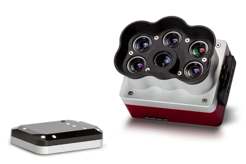
Micasense RedEdge-P
Micasense RedEdge-P
AGRICULTURE CAMERA FOR DRONES
Micasense RedEdge-P drone thermal camera, the smallest and most compact thermal camera designed for drones on the market today. Remote control and live video output + dedicated configuration app.
MAIN FEATURES
Augmentable memory
New removable professional storage standard in CFexpress, allowing more than two captures per second and instant turnaround time between flights by simply swapping cards.
Synchronized acquisition of high-resolution rgb and multispectral images
Simultaneous acquisition of up to six bands, allowing for multiple high-resolution results such as RGB, crop vigor indices (NDVI, NDRE, etc.) and high-resolution panchromatic.
Twice the spatial resolution of the previous rededge
With a high-resolution panchromatic imager, RedEdge-P enables higher resolution RGB and multispectral outputs, with a resolution of 2 cm when flying at 60 meters. Identify problems or smaller features first and make more reliable management decisions in a variety of use cases.
It works with what you have (drones, processing, flight planning)
This solution is compatible with a wide range of aircraft, from large fixed wings to small multirotors. Flight planning and data processing can be done with industry-standard tools.
Robust design
IP4X rated for dust and splash protection
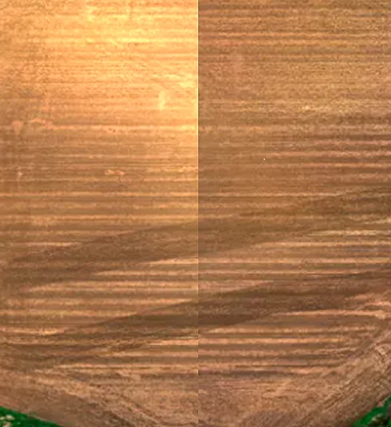
WATER MANAGEMENT
RedEdge-P can provide powerful information on water management. For example, color compositions using the NIR band (such as CIR) can help users identify excessively wet areas. In addition, areas that benefit from overwatering are highlighted.
PLANT PHENOTYPING
Manual measurement of plant characteristics is time-consuming. RedEdge-P captures more data in less time, allowing researchers to understand how different breeds react to certain environments and modify desirable traits to improve performance.
CROP HEALTH MAPPING
Low chlorophyll content is often an early indicator of plant stress. RedEdge-P captures the visible and invisible spectral bands. From the different bands, indices can be generated to see individual chlorophyll levels in plants and compare them over time.
FERTILIZER MANAGEMENT
RedEdge-P not only makes it easy to identify areas with low nutrient content, but also helps monitor the effects of fertilizer applications during the season and determine if, when, and where a new application is needed.
DISEASE IDENTIFICATION
RedEdge-P captures a critical part of the light spectrum for the study of plants (712-722 nm), called the red edge band. It is in this section of the spectrum that the first signs of stress begin to appear. Using red-band-generated analysis, growers can identify diseases earlier and act more quickly to stop their spread.
SPECIES DIFFERENTIATION
Some differences between species may not be visible to the naked eye. High-quality multispectral data enable species differentiation by highlighting characteristics such as chlorophyll content, vigor, and leaf size.
ADVANCED CROP SCOUTING
High-quality multispectral images provide advanced field exploration capabilities. Accurate, geotagged information about a problem can be gathered with a single flight, making it easier to assess the situation and determine the appropriate intervention.
WEED DETECTION
Analyses developed with multispectral data can identify and highlight weeds, which may have a spectral signature different from that of planted crops.
Calibrated multispectral images
Each RedEdge-P camera kit is equipped with a reflection panel for ground calibration and a DLS2 light sensor for irradiance and sun angle measurements. These radiometric calibration tools take into account different weather and light conditions, providing more accurate and reliable data that enable time series analysis and comparability of outputs over time.
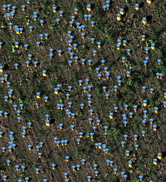
Powerful AI capabilities
With its panchromatic band, RedEdge-P enables high-resolution RGB and multispectral images for machine learning applications such as plant counting and advanced vegetation research applications.
RedEdge-P Sensor Specifications
Weight |
350 g (12.3 oz.) (RedEdge-P + DLS 2) |
|---|---|
|
Dimensions |
8.9 x 7.0 x 6.7 cm |
|
External Power |
7.0 V - 25.2 V |
|
Power Input |
5.5/7.0/10W (standby, average, peak) |
|
Spectral Bands |
Blue, green, red, red edge, near-IR |
|
Wavelength (nm) |
Blue (475 nm center, 32 nm bandwidth), |
|
RGB Color Output |
5.1 MP (global shutter, aligned with all bands) |
|
Sensor Resolution |
1456 x 1088 (1.6MP per MS band) |
|
Ground Sample Distance (GSD): |
7.7 cm per pixel (per MS band) at 120m (~400 ft) AGL |
|
Capture Rate |
Up to 3 captures per second raw DNG |
|
Interfaces |
3 configurable GPIO: select from trigger input, PPS input, PPS output, and top of frame signals. Host virtual button. USB 2.0 port for WiFi. Serial. 10/100/1000 Ethernet. CF Express for storage |
|
Field of View |
50° HFOV x 38° VFOV (MS) |
|
Storage |
CFexpress Card
|
Talk to one of our Experts
DroneBase provides you with an Expert Advisor
Able to recommend the most appropriate product for your needs
And answer all your questions.
Call us NOW!
+39.0541.1790411
Request information
Please enter your details below, our consultant will
will contact back as soon as possible and provide you with all the details!
