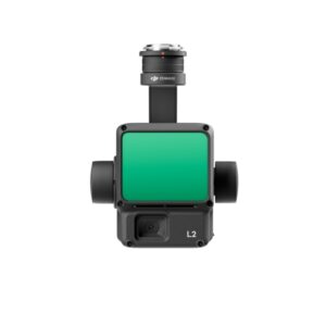
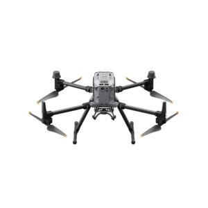
Today we introduce the all-new DJI Zenmuse L2 Lidar, a highly integrated system equipped with an improved RGB camera. This product represents a significant step forward from the previous model, the L1, offering exceptional levels of accuracy. The DJI Zenmuse L2 Lidar is an essential tool for professionals who employ some of the Chinese giant’s most renowned drones, such as the Matrice 300 RTK and Matrice 350 RTK.
Combined with DJI Terra software, the DJI Zenmuse L2 Lidar simplifies 3D data collection and offers highly accurate post-processing processes. This tool proves essential for activities such as surveys, mapping, inspections and infrastructure management. In particular, there is a significant reduction in the time it takes to measure and process the collected data.
The all-new DJI Zenmuse L2 promises amazing results in several areas. We have already explored the potential of its predecessor, the L1, in our article “DJI Zenmuse L1: Lidar for professional drones.”
THE NEW DJI ZENMUSE L2: AN EXCELLENT LIDAR The DJI Zenmuse L2, fully integrated with Lidar, a self-developed IMU system, a 4/3 RGB CMOS camera, and a three-axis gimbal, delivers especially efficient results when mounted on the Matrix 300 RTK and Matrix 350 RTK. The detection range has been increased by 30 percent, allowing not only smaller objects to be detected but also their details to be highlighted more sharply. This results in extremely accurate digital models.
The maximum point cloud emission rate of the DJI Zenmuse L2 is 240,000 points per second. The RGB mapping camera is equipped with a 4/3 CMOS with mechanical shutter and pixel size enlarged to 3.3 μm. With an effective resolution of 20 MP, detailed and color-rich images are obtained. Operating at an altitude of 150 meters, the point cloud model achieves an elevation accuracy of about 4 cm and a plane accuracy of 5 cm.
The software used by the DJI Zenmuse L2 is Pilot 2, which automatically generates reports on the quality of operations. In summary, this is a comprehensive tool ideal for surveying and inspection professionals. It also promises to be highly efficient even in dense vegetation and trees with high crowns.

© 2023 all rights reserved
WhatsApp us
Thank you for your interest in our solutions
Fill out the Form opposite and you will be contacted
by one of our Expert Advisors who will provide you with
The Best Solution for Your Need!
Thank you for your confidence.
Team DroneBase
Thank you for your interest in our applications.
Fill out the Form next to it to receive:
Request a consultation with one of our Experts to Point you to the Best Solution for Your
Necessity!
Thank you for your confidence.
Team DroneBase
Thank you for your interest in our applications.
Fill out the Form next to it to receive:
Request a consultation with one of our Experts to Point you to the Best Solution for Your
Necessity!
Thank you for your confidence.
Team DroneBase
Thank you for your interest in our applications
Fill out the Form opposite and you will be contacted by one of our Expert Consultants who will provide you with the Best Solution for YOUR NEEDS!
Thank you for your confidence.
Team DroneBase
Thank you for your interest in our Video Surveillance solutions
Fill out the Form opposite and you will be contacted
by one of our Expert Advisors who will provide you with
The Best Solution for Your Need!
Thank you for your confidence.
Team DroneBase
Thank you for your interest in our applications.
Fill out the Form next to it to receive:
Request a consultation with one of our Experts to Point you to the Best Solution for Your Need!
Thank you for your confidence.
Team DroneBase
Thank you for your interest in our applications.
Fill out the Form next to it to receive:
Request a consultation with one of our Experts to Point you to the Best Solution for Your
Necessity!
Thank you for your confidence.
Team DroneBase